Savour an Extended Fall Season
The Weather Network releases its 2020 Fall Forecast & Winter Preview
Oakville, Ontario, Sept. 14, 2020 – Chilly fall weather has burst on-to the scene well ahead of schedule across most of Canada, and many Canadians are now wondering if this means that winter is just around the corner.
To help answer this question, The Weather Network has released their fall forecast, along with their highly anticipated preliminary forecast for winter.

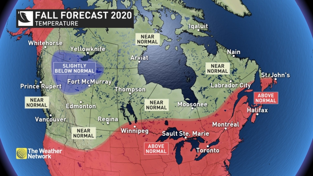
Fall Temperature Map (CNW Group/The Weather Network)
“Autumnal weather has arrived long before most Canadians were ready to say goodbye to summer, but this does not signal an early start to winter” said Chris Scott, Chief Meteorologist at The Weather Network. “October and November will feature extended periods of ideal fall weather across most of Canada, and we expect that the arrival of consistent winter weather will be delayed. This is in stark contrast to last fall which included a few historic winter-like storms and extended periods of mid-winter cold across most of Canada.”
Most Canadians can expect near or above normal temperatures during the fall, but parts of northern B.C. and Alberta are at risk of tipping to the cold side of normal. Once winter does settle in, the focus of winter’s fury is expected to be across Western Canada. Meanwhile Eastern Canada should see less severe cold than normal.
Here’s a more detailed look at the conditions expected across Canada this fall and winter:
British Columbia
After a very warm and dry start to September, a pattern change will bring cooler and much wetter weather for October and November with the potential for an early start to the ski season. The winter is expected to be colder and snowier than normal across the province.
The Prairies
After a shot of October-like temperatures during early September, we expect extended periods of mild weather for October and November. The arrival of consistent cold looks to be delayed, but we still have the threat of quick shots of early winter weather, especially across Alberta. A colder than normal winter is expected for much of the region.
Ontario & Quebec
After a quick transition from a hot summer to a cooler September, we expect extended periods of pleasant fall weather through October and November, along with a delayed start to consistent winter weather. Above normal temperatures are expected for the winter season. This means less severe cold, but an abundance of messy wintry weather can still readily occur with a milder pattern.
Atlantic Canada
Above normal temperatures are expected for the fall season. While quick shots of cold weather are still likely, we expect that the arrival of consistent winter weather will be delayed. Near normal precipitation is expected for much of the region, but there is a heightened risk for tropical systems impacting the region. This could result in parts of the area being wetter than normal. Above normal temperatures are expected this winter which will likely mean a higher risk for storms that bring a combination of rain, ice and snow.
Northern Canada
Colder than normal temperatures are expected across southern parts of the NWT and into southeastern Yukon. Above normal temperatures could extend into western parts of the Yukon. Most areas will see near normal precipitation. A similar pattern is expected this winter.
Keep in mind that even a mild fall can bring dangerous winter weather conditions to parts of Canada with little notice. As we move deeper into the season, Canadians should pay extra close attention to the daily forecast as winter weather conditions can develop and change rapidly. Canadians can be prepared for changeable weather by visiting www.theweathernetwork.com or by downloading The Weather Network App and creating an account for personalized and up to the minute forecasts.
|
The Weather Network: Fall 2020 Forecast |
||
|
Region |
Temperature Outlook |
Precipitation Outlook |
|
British Columbia |
Near normal, Below normal |
Above normal south and central; Near |
|
Alberta |
Near normal; Below normal north |
Near normal, Above normal south and |
|
Saskatchewan |
Near normal, Above normal |
Near normal, Above normal southwest |
|
Manitoba |
Near normal; Above normal south |
Near normal |
|
Ontario |
Above Normal; Near normal far |
Near normal |
|
Québec |
Above normal, Near normal north |
Near normal, Above normal east |
|
The Maritimes and Newfoundland |
Above normal; Near normal |
Near normal south, Above normal north |
|
Yukon, Northwest |
Near normal, Below normal |
Near normal |
Complete Fall Forecast details, including regional breakdowns, maps and charts are available at www.theweathernetwork.com/fall.


